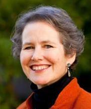
In this episode, Professor Michael Watts interviews Clancy Wilmott, Assistant Professor in Critical Cartography, Geovisualisation, and Design in the Berkeley Centre for New Media and the Department of Geography. Professor Wilmott comes to UC Berkeley from the Department of Geography at the University of Manchester, where she received her PhD in Human Geography with a multi-site study on the interaction between mobile phone maps, cartographic discourse, and postcolonial landscapes. At UC Berkeley, Professor Wilmott is teaching graduate-level combined theory/studio courses on locative media, cross listed courses in digital geographies, as well as core curriculum on geographic information systems in the Geography department.
Produced by the University of California, Berkeley’s Social Science Matrix, the Matrix Podcast features interviews with scholars from across the UC Berkeley campus. The Matrix Podcast is hosted by Professor Michael Watts, Emeritus “Class of 1963” Professor of Geography and Development Studies at UC Berkeley.
Listen on Apple Podcasts or Google Podcasts.
Related Materials
- Watch the video on YouTube
- Purchase Professor Wilmott’s Book: Mobile Mapping: Space, Cartography, and the Digital (MediaMatters)
- Follow Clancy Wilmott on Twitter
Podcast Transcript
[UPBEAT MUSIC]
Woman’s Voice: The Matrix Podcast is a production of Social Science Matrix, an interdisciplinary Research Center at the University of California, Berkeley. Your host is Professor Michael Watts.
Michael Watts: Hello and welcome to Social Science Matrix Podcast. My name is Michael Watts and I’m the host for today’s discussion and interview. These podcasts are really an opportunity to showcase some of the social science research that’s being conducted on the Berkeley campus by faculty, by postdoctoral fellows, by doctoral students. And we particularly tend to focus on the sorts of critical social science that’s being conducted on the Berkeley campus in and around the most compelling and important social, economic, political challenges of the moment.
Today, I’m delighted to have with us Dr. Clancy Wilmott, who is a professor in the geography department on campus. That’s not quite true because Clancy was hired immediately prior to COVID. She at that point, had a position at Manchester University and essentially has been trapped in the United Kingdom where she is talking to us right now.
So she is, we hope, now able to come relatively soon. Clancy is a geographer by training. She actually received her undergraduate education at the University of Technology in Sydney, Australia, with a specialization in communications, but also international and cultural studies.
She then moved to the UK and completed her doctoral work in geography at Manchester University, where she then held a position teaching largely on questions of cartography, geographical information systems, the new raft of geospatial technologies that we perhaps now have come to take for granted.
She is currently teaching on campus and will be teaching in both geography and the new media studies group on the Berkeley campus. She also has a new book just out, which we’ll be talking about in just a second entitled Mobile Mapping, Space, Cartography, and the Digital. And she’s written extensively on geovisualization, critical cartography, forms of locative technology, phone maps, cartographic discourse and so on, with a particular focus on urbanism and cities. Clancy, we’re delighted to have you online with us today. And thank you so much for generating a little time to be with us today.
Clancy Wilmott: Thank you so much for inviting me. I’m delighted to be here. Really looking forward to it.
Watts: So let’s begin with a question that’s not particularly about your research per se, but since we’re in the electoral season here in the United States, the elections occurred just over a week ago. And of course, we’ve been swamped with maps, forms of spatial representation over the last 10 days. Not peculiar to American elections. It’s elections in general.
But given that you’ve spent most of your professional life thinking about spatial representation, thinking about maps, mapping, who gets to map, and particularly the new media, I wondered, firstly, just as a way of getting us going, what’s your reflection as someone who’s thought a lot about those technologies and how they get deployed as part of the electoral process?
Wilmott: That’s a good question. I think by sheer coincidence, the night before the election, the Monday evening, my time, so Monday morning US time, I was teaching a large undergraduate class about gerrymandering and the problem of– the MAUP problem, which is the Modifiable Area Unit Problem, which is basically this big issue where when you start with a piece of data. So every single person casts a vote. And then you generalize that data or aggregate it up into a shape, you lose the fine grain of what’s hidden underneath.
And I think what’s been particularly interesting for me in watching this election is actually looking at the way in which maps aren’t just about communicating geographic information anymore, but they’re actually part of a, I suppose, a media storytelling narrative. And each different newspapers have their own mapping projects.
So the San Francisco Chronicle, for instance, has a whole raft of different interactive maps and the New York times, too. But what I found was really interesting, there were two maps that started circulating around social media. And the first was this argument that basically geography doesn’t vote, people do. And it rearranged these large areas of relatively unpopulated space and actually realigned the blue and the red states to actually more accurately reflect the population rather than the geography itself.
And I think when you look at a country like the US, and it’s the same with Australia, and to a degree the UK as well, because rural areas that take up more space but tend to have less population, they tend to be over-represented cartographically on those maps. And so it looks like a hell of a lot more people are voting one way than they necessarily are because of this problem with the map.
And I think for me, that was a really good example of actually how geography itself kind of tells fibs. It lies in some ways, and cartography particularly. But also the way in which these new tools, we have these new digital cartographic tools, like even something as simple as a GIF or a “jif,” G-I-F, can actually demonstrate some of these big cartographic problems that we teach our students about all the time to this general audience.
And I think the second map that I really enjoyed was one that didn’t paint the states, red and blue, but instead created these gradations of purple to actually try and show a much more nuanced story that didn’t lump everyone in Arizona together voting the same way or everyone in California. But actually gave a much more detailed story about how location and how population actually is a lot more complicated than these, I suppose, made up shapes that are states that are kind of imagined.
And I think for me, this kind of– it was really joyful to see a more nuanced cartographic discourse. Maps being used not as tools just to try and represent a so-called truth but to actually try and make arguments about their own limitations in terms of how we represent elections. I really, really enjoyed watching those kinds of conversations unfold through maps.
And I think it was because mapping has perhaps moved a little bit away from this traditional field of GIS and into something that’s much more media based. It’s data visualization. It’s different kinds of cartographic argumentation.
So I thought it was interesting that basically, I’m teaching my students about this problem, that you cannot see individuals. That basically the shape of a state erases all the complexity of the lives inside in it. And at the same time, there are all these incredible maps that are trying to make these arguments counter to that. So I thought that was great. Really great.
Watts: It was interesting that you mentioned those two newspapers and the degree to which now quite sophisticated forms of visualization are now commonplace. I mean, particularly in a newspaper, for example, like the New York Times, which has undergone some type of revolution in the last few years where you would, in the past, have rarely seen a map. Now, particularly because all of these things are available online, of course, you have all sorts of interactive forms of mapping that are really extraordinarily rich and can fulfill a very different set of purposes really.
Well, that’s a nice segue into where I wanted to begin our conversation, Clancy, and that is to just start with the very idea of what a map is, what mapping entails, and who are the mappers. These are issues that you begin your book with actually.
And I start because I think often within the social sciences, people make use of maps a lot and yet they’re not perhaps thought of critically. And you yourself and many people in our discipline identify as critical cartographers. So let’s start with how you think about the map and whether it is a type of– and in what way is it a miniature version of the world? Is it a detached and elevated view of the world or a part of the world from above?
Is it, in some sense, truthful? Is it objective and neutral? After all, a good map can get me from A to B. It’s a simplification, of course, but there are a series, presumably, of rigorous rules that allow one to transform or the map to correspond to the territory or the landscape. Is this the way that we should think about maps or does that need to be unsettled in some way?
Wilmott: I think it needs to be unsettled. Maps are really complicated. And I think for me, the first point of unsettling. And it’s not a distinction that a significant number of critical cartographers draw but it’s one that I found helpful in trying to hone my own thinking out of just a critique into something that’s a little bit more optimistic, is to separate out two concepts which is mapping on one hand and cartography on the other.
And I think the reason it’s important to separate out these two concepts is that, for me, cartography, it’s a scientific endeavor. And it’s born out of a particular set or ways of thinking that place questions of truth and objectivity, also questions of universalism at its heart. And I think this is how we traditionally understand maps. And when we talk critically about cartography and mapping, we’re usually talking about this kind of, I suppose, way of knowing space through lines drawn on paper, through numbers, through coordinate systems, et cetera.
Mapping, on the other hand, and this is why I start in the book with the question of what is a map, who are the mappers, what is mapping. For me, mapping is much more– it’s much more intuitive. It’s much more performative. It’s about drawing relations between things in the world and then representing them in certain ways.
And so maps don’t necessarily have to be visual in this sense. We can think about– and I think for me, the distinction between, say, a map and any other piece of art is that it’s specifically spatial relations. We’re specifically talking about spatial temporality where things are arranged compared to other things.
And I think for me, mapping is something that we all do all the time. And when we imagine how we’re going to get home after work or we imagine what home looks like, we’re always undergoing this kind of representative mapping of the world, of bringing it together in a way that is understandable to us. And I think everyone’s maps are vastly different. And I think if you’ve ever tried to navigate with someone who moves through the world differently to you and had a fight about it, then you understand that mapping is this heterogeneous process.
And I always have a top down, very cartographic map in my head. I grew up in a family of orienteers. And orienteering is a sport where you run with maps going from A to B. And so my entire life has been thinking about the world in this very cartographic way. But when I travel with other people and they talk about landmarks. Oh, you’ve got to go all the way to the Burger King and then turn right. I’m like, I don’t know where the Burger King is. What’s the name of that street. And so you get these different heterogeneous ways.
What I think cartography does, it serves a different kind of purpose, which it tries to bring into some, I suppose, communal understanding how those representations should be. And then pins them upon principles of accuracy, so making sure that the distances that we imagine between things are consistent. So there’s a consistency question. And that these principles can be applied universally to all places in the world.
And I think that doesn’t necessarily have a lot to do with our experience of mapping in the world. I think sometimes places will feel further or closer than they are now. And I think the recent pandemic is a very good example of how places feel further away than ever, even though they’ve not geographically changed in terms of distance. So for me, I think that’s the key distinction here, is mapping is this way of drawing spatial relations, and imagining them, and communicating them. Cartography is a much more formal practice.
Watts: Can we just spend a moment on that formal practice? You use a very important term in your book called cartographic reason, which you in part take from my old teacher, actually, Gunnar Olsen.
Wilmott: Really?
Watts: Yes.
He was my teacher in Oxford and Franco Farinelli. So could you just unpack that for us a moment? so on this more universalist cartography, a science, a set of rules that turn on points, and distance, and projection, why is that important for both your book and for us to understand?
Wilmott: So I think within thinking about critical cartography and mapping, there has been a kind of move away from understanding the map as a discrete object that exists on its own in the world. When you read a map, people draw on maps, the map changes depending on the landscape. So maps are always kind of in becoming, they’re always changing. And we’re seeing it increasingly in the last 70 years or so, cartographic tradition changes as well. The way we represent things. I mean, increasingly every map looks like a Google map now. So we’re getting these changes in cartographic tradition.
What cartographic reason offers as an idea and the way that I’ve taken it from a Farinelli’s work and Olsen’s work and tried to– well, applied it to this particular way of thinking about cartography is to understand cartography not as a doing necessarily or as an object, but as a way of thinking and a way of thinking through acting or through creating as well.
So Olsen makes this constant discussion around what he calls a chiasm of thought and action, which for me, basing a lot of my work as well on particularly the early writings of Michel Foucault, this idea of the speech act. So I think for me, what cartographic reason, it’s a way not just of representing the world and thinking about it, but it also inscribes its own truths into the world.
And I think Farinelli describes the way in which following the enlightenment, the map or cartography is not just a descriptive. So people like Baron Von Haussmann would look at a map and then use that to draw out the boulevards of Paris. So it’s this basic way that the object itself becomes bigger than what it’s representing.
And so for me, cartographic reason, it’s about understanding that there is this principle of universalism within the Cartesian structure of coordinates so that all things can be described via coordinates. And there are lots of examples where that gets very, very messy.
It’s also about the way in which the world can be inscribed and territorialized according to a set of principles that was built in a very specific place and time as well. And these principles are transported, this way of thinking is transported by people like Lieutenant James Cook to Australia who use these principles to then try and describe this other kind of landscape with varying degrees of success.
And it’s also about this idea that you can capture the world in lines, in numbers, in representation. And then you can use those representations means to then make decisions about that world. To make decisions on how you should change it. To make decisions about where you might put mine. So it’s this way of thinking that is both speaking and doing at the same time.
Watts: And I take it that a key part of that thinking and doing and the way in which that cartographic reason gets deployed is absolutely central to state building and to Empire. All imperial projects ended up mapping. And land surveys, in exactly the same way, that the establishment of what we take– presumably, which we call the modern nation state was about making things legible. Where the borders are. And where people were located. And how many people were there that you could tax them, et cetera. So presumably, cartographic reason was a central part of that modern project of state building.
Wilmott: It wasn’t just a central part. You cannot disentangle mapping from this modern state building that particularly happens in the 19th century. And so the cases I look at in my book are both Sydney and Hong Kong, which are these very modern colonial British imperial states.
But what happens in both of these places and many other places as well is that the mapping, in a way, precedes territorialization. So before these spaces are claimed, before they are territorialized, mapping occurs. And then I think it’s not necessarily coincidental then, so in 1997, following the handover of Hong Kong, so Hong Kong Island and the new territories in Kowloon back to the Chinese government that the Chinese government then embarks on a project of remapping as well, of going back and remapping that land.
And so part of this necessary centralisation of mapping to the state formation– and it’s important as well. And this is why I use the term cartographic reason rather than just cartography. If we understand cartographic reason or cartography as a way of thinking and doing, then it’s not just the act of mapping itself either. It’s a whole host of associated actions as well, like surveying, like census data, like a lot of geological mining.
It’s all of these practices together that seek to basically describe the world in such a way, in this consistent way of knowing, this universal way of knowing so that they can almost speak to each other as well. And so in Australia, before they could even land, they had to measure the depth of the water in the first instance.
And one of the first things that happened after Hong Kong was settled, the island, is they drove a copper bolt into the pier of the naval dockyard. And they used that as a center point for agreeing, well, this is what sea level looks like. And so it’s about forming these agreements and about trying to bring everything into line together.
And it doesn’t end with colonization either. It’s a continual project of constantly refining all of these forms of spatial representation into a continuous system across the world. And I think as well– so it’s not just– cartographic reason is imperial way of thinking as well.
Watts: That’s terrific. I mean, you make the point that these forms of spatial knowledge, spatial visualization are in the business of calculating or in the business of classifying. But you also, again, early on in your book say that those same cartographic practices are in the business of, I’m quoting you now, “controlling bodies in space.”
Can you talk a little bit about that more? I guess, it’s partly about what these maps are used for, that spatial knowledge is used for as part of a whole raft of apparatuses you’ve just described. But what, for you, is important about that. Controlling bodies in and over space in thinking about maps and mapping?
Wilmott: I think for me, it’s central to the fact that landscapes, they’re lived, right? And so the idea of the colonial project is one that is about order. And maps play a huge role in that. And I think the continual re-imagination of cartographic projects throughout the histories of both Hong Kong and Sydney see a constant battle not just with landscapes but also with people.
And so early on in documents in Hong Kong, they start laying out land parcels that people can build on. But there’s constant miscommunications and people go and build houses on the wrong land parcel. And a big question then is raised, OK, well, who do we get them to move their house, what happens.
And similarly, as Chinese immigrants keep coming into Hong Kong, they start building in ways that are not pre-advised by the colonial government. And this creates all kinds of problems for them in terms of controlling this population through cartography.
Because I think maps, particularly colonial maps, they focus on buildings. They focus on habitation, on dwellings, as well as resources. So it’s not just– and I think this is particularly the case when we look at somebody like Sydney and Hong Kong, is that these are cities emerging. They’re cities that are prestaged in these maps. And you see the dwellings in early maps of where people are living. You can see the plans of where people can live as well so you see the plan of the city beginning to be etched out before it’s been built in pencil on those plans. And so for me, I think that’s one element.
And I there’s a second element that is joined in just the historical application of maps but the more contemporary application of maps. And I think this is where my understanding of cartographic reason, I suppose, departs a little bit from Gunnar Olsen’s.
In that, for me, cartographic reason isn’t just an alignment project around Cartesianism. It’s not just about the coordinate system. But it actually takes up a whole host of ideas that you find around universalism in Leibnitz’s work as well. Also, this kind of material universalism. So it’s not just about creating a grid that goes outwards forever. But actually our ability to calculate doesn’t just get bigger and bigger, it gets smaller, and smaller, and smaller. And it becomes inside ourselves as well.
And so in a way that we can begin to see the building where people can build in early maps, we’re beginning to see further determination about where we might go in space through our everyday use of maps. And it’s not even so much saying that we necessarily have to obey but this increasing datafication of our bodies– and I think for me, this is still part of this same universalist project where we’re basically able to now translate our journey into a certain number of footsteps which we can then use to measure against how far we’ve gone.
And in the same way, the algorithmic way in which a Google map decides which way you should go is entirely determining– ooh, sorry, controlling a body in space. It’s entirely about trying to funnel people into certain ways. It’s just in a much more subtle way.
Watts: Let me just ask you one last question of a more general sort on maps, and mapping, and cartography before we get into your book. And that is that insofar as cartography was a hugely important tool and part of a set of apparatuses for state building. In other words, maps were part of seeing like a state, as James puts it.
But this was a very contentious process. Some people don’t want to be seen or some people resisted the idea of being mapped. There’s a whole history of surveyors being shot and killed and so on. And where I’m going with this question is, in our discipline, there’s also a tradition which you’ve written about and others referred to as counter mapping.
And I’m just wondering if you could talk a little bit about, in a sense, both the contentious and the type of counter movement sometimes in which maps are used– other types of maps, perhaps predicated on different systems of calculation, let’s say, are then used to resist the power of state-backed maps, let’s say, something of that sort. I wonder if you could talk a little bit about that.
Wilmott: So I think the way I would summarize this is there’s two big questions in this discussion of counter mapping. And I personally think they’re a little bit irresolvable. And I know certain geographers like Agnieszka Lozinski have tried to articulate what the actual issue is here. And I think it’s a difference between critique of purpose versus critique of the representational tools being used to describe.
And I think there’s no answer to this because I think it is such a deeply situated question where there’s some really incredible projects across the board where people– so for instance, Eddie Mabo in Australia, who was responsible for taking the question of Native Title, the right to own land or the right to ancestral lands for Aboriginal people to the high court submitted a map to the high court, which is one of the most, I suppose, powerful maps in Australian history.
And it was written on a piece of note paper which still has the blue lines and the round puncture holes in the top. And it was basically written. It is in pencil. And he submitted this map of land that he claimed was his ancestral land to the High Court of Australia. And the case won. So it wasn’t for nothing either.
And so you have this question of, you can count a map, you can redraw boundaries. A lot of the times, people will go out and information that they’ve been told about themselves that they don’t feel is true, they will find new ways of drawing new boundaries of providing new data around– there’s a lot of citizen sensing where people provide new environmental data around air pollution, or radiation, or water quality.
There’s a lot of counter mapping as well, where Indigenous groups will go out and remap their territory in order to be able to make claims about their right to own that against states that seek to dispossess them or are unsure of those claims. So you’ve got this whole thing where you’re using these tools, which again, I would agree are deeply flawed because they are based in colonial ways of thinking, ways of thinking that are very much about universalism, rationalism, around resource control, around capitalism as well. They use these tools to basically try and make these claims backwards– or back towards power. So you get this counter mapping power.
At the same time, there’s also a critique that a lot of people who do counter mapping also appreciate, which is the tools themselves are really problematic. We still use Google Maps for a lot of counter mapping. And Google, as a corporation, owns a huge amount of our spatial information, in the same way that the Landsat satellites that a lot of people use for making maps are still owned by the US government.
So you’ve still got these problematic tools and the limits. And if you’ve ever used a GIS or a Geographic Information System, the ways in which we can represent the world are really, really limited. They’re still based around points. We still have a meridian that’s based that runs through London or through the observatory in London at the Royal Naval Academy.
So we’ve still got these systems that are very deeply problematic. And I think for me, my research is always about trying to manage both at the same time. We need better tools. But at the same time, not everyone has the luxury of waiting for these tools to be made either. And I think for me, this is where critical cartography, critical GIS, critical mapping, all of this debate is at this point at the moment of just waiting because I’m not sure to what degree the need for purpose versus the need for the best tools that are the most emancipatory is ever going to be resolved in the near future. So that’s kind of where I see that as being at.
Watts: That’s terrific. And that’s a lovely segue then really into your book, Mobile Mapping. So the media question one needs to begin with is how does digital mapping make a difference? What’s different about it? And in fact, if I can quote you, you begin your book, I think it may be the first line, I can’t recall. It’s that you say, “what does mapping mean in the age of mobile digital media? Who are the mappers? What is the map?”
So let’s just start then with the fact that all of us have become, by virtue of owning a cell phone, a photographer and a mapper. So let’s start there. What for you is distinctive about this shift away from, as it were, the traditional mapping devices that we’ve talked a little bit about on paper, et cetera, to the digital? What do we need– how do we need to think about digital maps differently? Or indeed, are they that different?
Wilmott: I think, again, it’s a two-edged answer. Which is on one hand, they’re not that different at all. The same systems of thinking are still very much in place. The same geometries, a lot of the same coordinate systems are still in place. A lot of really old rules. And I think what’s particularly interesting is that when you look at something like Google Maps, they get their new maps from going over old maps. So they’ve still very much inherited these deeply problematic ways of thinking about the world that are really limited.
And when you take these limitations and you place them into spaces like Sydney and Hong Kong, which are contested spaces, when the land or the ownership of the land is contested, the histories are contested, those are ceased to be just problematic and they become weaponized politically.
So on one hand, you’ve still got this continuation of thinking. And I think a continuation of belief in the map as a kind of truth rather than a storyteller as well. At the same time, what the digital brings to my mind technologically is an extension of those principles of thinking and basically extends those ways of thinking into realms that we hadn’t necessarily understood as being cartographic beforehand.
And I think, by way of example, so for instance– actually, there’s two points I want to make here. Firstly, by extending it, basically, it’s allowed for an interoperability between cartographic systems and systems of big enumerative data as well.
So before this movement where you would use or you would geolocate data or information, whether that’s economic data, whether that’s money, or whatever, and if you’re going to put that into space, that would have to be done manually or quite slowly and arduously. Now there’s this very easy interchange between cartographic or geographic data and all other kinds of data. It’s very easy to make data geospatial one way or another. it’s pretty easy.
On the other hand, we’re also seeing the application of the spatial principles of representation around geometry, around numeration, calculation, quantification, extending well out of our phones as well, and into so many different new technologies as well.
So from things like the wearables, like Apple Watches which will buzz depending on which way you want to go to the new iPad, for instance, has a LiDAR function that enables you to map the world using sensors so that you can place it. Video games use the same kinds of architecture or architecture programs as architects. And so you’re seeing this folding in of all of these different spatial technologies together that we use at once for fun, but also for more serious concerns.
And so for me, thinking about what the digital map is, it’s not just a map on a computer screen. And it’s increasingly not just a map on your phone screen either. You use any app. So if you’re using Instagram, then you’ll be geotagging those photographs. If you’re using Snapchat, you’ll be geotagging. So everything is being spatialized that you do on any device. And the ways in which that’s being spatialized are becoming more complicated as well.
So your phones have accelerometers in them, which are little crystals that change according to– they measure change. And so if you’re moving faster or slower, the accelerometer can measure this spatial relationship of change. Similarly, autonomous vehicles are not just using GPS devices but they’re folding the data they get from GPSs into other kinds of data they get from sensors as well.
So we’re actually seeing this extension of the universal cartographic principle into pretty much anything that’s spatial. And as geographers, we pretty much everything spatial. So robots are mapping bodies and using those maps of bodies to then do surgery. And so you’re seeing this extension of these cartographic principles which were originally just about spatial order, about imperial imaginations, about control over space and bodies into control over so much in our lives. Everything can be mapped and everything can be datafied. And so therefore, everything is now subject to these really old school ways of thinking cartographically.
Watts: What is the significance given that sort of spatial extension that you’ve described? Of the fact that presumably, digital maps entail a type of real time experience in which the old map did not? Is that of any significance for you or not?
Wilmott: Yes, it is to some degree. Partly because again, navigation is pretty old. And I think a lot of the ways in which we have navigated historically– so the fact that we can now see ourselves on the screen. So I mean, Bruno Latour writes about La Pérouse, traveling up the East Coast of Australia using Lieutenant Cook’s maps.
So maps have always had this kind of mobility. We’ve always referred to previous maps to try and determine where we are and to navigate through the world, generally speaking. I mean, there’s lots of different navigational traditions as well from Polynesian wayfaring, et cetera.
But the appearance of the GPS, which is something– it’s a little bit separate. We often think of it as being part of the map. But it’s actually a layer on the map which is based not so much in cartographic tradition but in a particular scientific tradition of positioning that was developed after the development of the radio by [INAUDIBLE] Marconi.
And so what you’re actually seeing is this kind of speeding up of us being able to enumerate ourselves in our position in the world and then the speeding up of us being able to put that on the map. And so I’m writing a piece at the moment about the history of positioning Australia because Australia is a really interesting continent because it moves very quickly North so they have to constantly update the positions.
But there’s a whole cooperation in the Pacific around trying to position the various points of the Pacific against each other. And there was a cooperation between Japan and Australia, and this is in the early 19th– early 20th century, apologies, 20th century trying to do this kind of work. But of course, the radio is bound up in histories of empire. [CHUCKLES] So it’s all bound up together.
And I think for me, again, it’s just a classic example of the way in which the digital map now can see all of these different disparate technologies that were previously part of different realms, so radio on one hand. Cameras on the other hand, maps are now all able to be brought together onto single devices and cycle very, very quickly between those applications.
So you can take a photo, figure out where you are, attach a tag to it, and then represent that on a map all within the space of a few seconds. It doesn’t happen instantaneously. It just happens much, much, much more quickly than it’s happened in the past.
Watts: In your book, you refer to mobile mapping as thinking, being, and doing all at once. Is that exactly what you’ve just described or what you meant that turn of phrase to imply?
Wilmott: Yes, basically. Yes. And I think what’s important as well– and I think I started out with the project expecting us to be much more imprisoned by the phones, the maps that we use. And I think probably mea culpa, a little bit too much reading of Foucault led me to that hypothesis.
But when I got there, actually mobile mapping, it’s not always just about the phone. I think for me the question was what happens when we decenter the technology and understand ourselves as being in constant thinking, being, doing all at once. And what happens when we bring the phone– well, we don’t bring ourselves, our social lives into the phone. But rather we bring the phone into our social lives. And we choose to focus instead on our practices, our thinking, being, doing, rather than focusing on what the phone itself can do. So for me, mobile mapping is about– it’s more than just technology. It’s our way of engaging, of mapping while moving in the world.
Watts: Can I just run with that a little bit and raise the question of in your book the type of, if you like, research design part of your book. And that is you chose two cities, Hong Kong, Sydney. And the, as it were, the empirical spine of your book are a series of walks that you took with individuals. Can you talk a little bit about that and why you chose that means as opposed to driving in a car with a GPS or some other set of interfaces with forms of spatial– geospatial technology?
Wilmott: Partly I was interested– so I had done previous research about the way in which geolocative technologies had– so I was looking particularly at Foursquare which was a check in app around 2010. Kind of reshapes your urban imaginations and memories.
And so I’ve done a lot of research on the fact that the phone plays a big role in giving us language and playing a part in how we remember where we’ve been, and what we’ve done, and also blurs our experiences between what we’ve actually done and what we’ve read about on the internet as well.
So I had already done that kind of research. And I was thinking a little bit more about the fact that I had done this research in Sydney and I hadn’t really given Sydney a chance to speak back, in a sense, to counter map my narrative. And what I was interested in doing was actually asking the question, well, to what degree is this just my experience and what degree does context make a big difference in the way in which we engage mapping and maps. And to what degree does the history or the spatiotemporality of where we map of that mobility make a difference.
And so what I decided– I could have done interviews but I was actually much more interested in trying to garner a sense of impromptu whatever. I think for me, it was the opposite of what I think a lot of research designs are. It wasn’t about specifying an object that I wanted to research. But instead to see to what degree does that object actually permeate or infiltrate into our everyday experiences.
And so what I did was– I was doing archival research at the same time, reading about the city, and going into the archives, and looking at a lot of archival documents that don’t really make it to see the light of day because they’re really messy sketches that surveys had made very early on.
But what I wanted to do with people was say, OK, so can I just hang out with you for a few hours. Can you just take me somewhere. Can we just do something in the city. And I’m interested in how you engage in practice of mobile mapping.
Like, how do you know where you are. How do you know where to go. How do you decide which way to go. How do you know what you like and you don’t like. How do you actually map this space in and of itself. And then to what degree does the phone actually determine what we think of as Sydney. To what degree do these phone maps actually determine that. Or to what degree is it much more complicated than that. And I chose Sydney because I had already done the research there.
And I chose Hong Kong for a similar reason where I was actually considering a third case study in Los Angeles but decided it was actually a much more complicated space than I think I could have done those three cities in a single project. But Sydney and Hong Kong have a lot of comparabilities in a way, partly because they’re both on the edges of the British empire. So these spaces that were very specifically designed to be outposts as well. They’re edge cities.
And they were both, I suppose, colonized from the edge in as well. So they start at the shoreline and they colonize inwards as well. And of course, they’re both doing most of their big city building projects at a very similar time. As anyone who knows their urban history, the 19th century grid plan becomes this big thing. And in Sydney and Hong Kong, it fails miserably because there’s a lot of hills and they’re both really terrible examples of the grid plan.
So that’s why I chose. It was basically just to go, well, OK, well I’m going to give the landscape of Sydney a chance to intervene in this. And I think I just wanted to try and find a way of saying, actually, is it possible to study technology and maps as well without focusing on the maps as well. I think there have been a lot of discussion in previous writing about the power that the map has. And I suppose what I was interested in, well, what power does the map not have. What is the limitation of that power.
Watts: And what surprised you in your findings across these two cities with respect to that question?
People are surprisingly inconsistent. People are terrible [CHUCKLES] at doing what they’re told. And I had expected some kind of resistance. But one of the interviews, Cassie, she had– and I mean, she’s the same generation as me, knows how to use technology very well, writes for digital media companies, and she decided that she was going to walk from her workplace to the main station, Central Station in Sydney.
And she had gone to Google maps, written out the instructions on a little sticky note. And then we followed the instructions for the note. But halfway through, she veered off from the instructions and went down the wrong street. And I knew that she had gone down the wrong street because I suppose being a geographer, I’m usually very, very aware of where we are.
And I asked her three times what the name of the street was. She just thought it was the same street. So we eventually got to Central Station. I said to her, I’m like, you know you didn’t follow the instructions, right? You went down a completely different street. And she’s like, no, I have not. No. And she’s like, that’s why you kept asking me what the name of Crown Street was when she kept saying it was Elizabeth Street. I’m like, yes.
And this happened so often. The amount of time I spent holding my tongue while people got very, very lost and missed. And the way then as well, not only did they just find themselves to be very disobedient bodies, like they’re very, very disobedient. The landscapes themselves are also disobedient. They don’t obey what cartographic reason or this kind of way of thinking wants them to do. And this is just, I mean– [CHUCKLES]
Watts: For example. Give us an example of that.
Wilmott: So people had stories over and over again. So for instance, people would talk about the shape of the hills and the way in which the hills fill this kind of shape. But the street itself– so in Sydney and Hong Kong, there are a lot of very straight streets that go very sharply down hills. And I mean they’re very dangerous roads. But they were trying to enact this grid plan and this is what they decided to do.
And people would describe ways that moving that were counter to the cartographic plan. They’re like, no, we can’t go that way because yes, the street is too steep, or it’s raining and the street is really slippery, or it’s really dangerous. Also, people talked often about the way in which–
So storms make a big difference as well. So Ben, for instance, wanted to go to a Green Park so he could sit and talk. And he looked at the Google Map and he saw this little green patch. And he’s like, oh, let’s go to that park. And we got there and he’s so disappointed. He’s like, I thought it would be more like park and less like sporting fields. But it’s the middle of summer in Sydney and everything is brown. Nothing is green.
And I think when you see this kind of green patch on the map, you have this expectation that the landscape will look like this very ordered British park from whence this kind of mapping comes. And when you get to Australia, it is full of really dangerous bugs that want to bite you. And it’s plants that sting you. And the dirt is really hard. And the grass is really rough. And the sun is really hot. And the trees are straggly gum trees. And it’s all just very disappointing all the time. And the cartographic reason sets up this promise and the landscape’s like, [CLICKS] no.
And the final example I think this is my favorite example, is when I was walking with Cliff in Sydney. There had been a storm the night before. And we were walking along the shores of Botany Bay. And we could actually see where Cook landed when he first came there. And where they shot at the Aboriginal people. And we could see La Pérouse, where La Pérouse landed on the other side of the Bay.
So we’re walking across this pretty historic site. And there had been a storm the night before. And it was quite windy. And there were these big mansions, very American-style houses built right, right close up against the Bay. And there was this little digger that was basically running around trying to scoop up all of the sand that had been blown over the dune and onto the pathway in the front yard of these houses. And trying to scoop it back up and put it back on the beach.
But as it did it– and I don’t have very good footage of this because I had a little camera. And I wish I had but it was so windy, it was difficult. As the digger got the sand, it would then go back towards the beach but the wind would blow all the sand backwards even further into the people’s houses because the bay is really windy.
And so I think there’s always this kind of tension between these ordered spaces that the path is a path and not the beach. And when you look at the path on the map, it looks like the path and it’s not the beach. And someone’s property is also not the beach and not the path. And this kind of separation or this expectation of separation of landscape compared to what really happens in the world, which is messy, and mucky, and sandy, and brown, and disappointing. So I think for me, it was this constant hills, and koalas, and bugs, and heat just kept interfering with the cartographic imagination all the time.
Watts: Terrific. Thank you. Let me ask you one last question. We’re almost out of time here. But I do want to explore this one because this is some of your newer work. You’ve also been writing recently about what you and others call platform urbanism and its significance with respect to cities and city life of what you see as a shift from, I’m quoting you now, sort of traditional cartographic structures of the sort that we were talking about before, peer to peer exchange.
And particularly, you take a look at a couple of start up companies that are using blockchain mapping as potentially something that might provide in relationship to that centralization of data and information that you were invoking earlier with respect to big companies like Google, et cetera. I wonder if you could talk a little bit about those forms of technical innovation and the type of mapping that that potentially might entail as you see it.
Wilmott: [LAUGHS] For a couple of minutes. So I think for me, what is interesting is part of the critique and we talked a little bit about this when we discussed this sort of question of counter mapping is that cartographic data is really, really closely funneled into very few platforms.
So you’ve only got a certain number of different organizations, sometimes corporations, sometimes governments, sometimes collectives, I suppose, you could call OpenStreetMap. But there’s this limitation of who gets to control this cartographic data.
And I think at the heart of this question of our tools of representation aren’t good enough. They’re not democratic enough. They’re still based in these really imperial ways of thinking about the world and I would say rationalist in the extreme.
There’s this question of, well, what tools can we use. And I thought the blockchain mapping example is particularly interesting. So there’s been an emerging area of research about the possibility of using blockchain systems for managing country or Indigenous knowledge management. So there’s this possibility.
And I think the attraction of a blockchain system is that. It’s open so everyone can see what’s in it. No one can change anything inside it without everyone agreeing to it. And everyone still retains control over their part of it as well. So you’re not giving your data to Google who goes and does whatever. You have this agreement in place. There’s this contract exchange.
And a range of companies– and so I’ve been sort of following this debate around blockchain as a possible way of decentralizing ownership over knowledge around geography, et cetera, or country management. And these two companies have sort of come along and basically made an argument for a much more decentralized mode of mapping where rather than relying on the GPS satellites that are owned by various consortia, whether it’s the European Union or the US government, instead we can actually engage with each other to be able to verify our location using triangulation on the ground.
And so this relates, again, back to what I was saying about sensing, this rise of the sensing technology of these cartographic technologies that are still the same ways of thinking but are much more embedded in everyday practices. They’re much more continuous. They’re happening faster and all the time.
And so for me, I find these systems to be kind of interesting. I am concerned, however, the emphasis on blockchain as a mode of exchange, and that’s usually monetary or financial exchange, this idea of constant incentive in capitalism. But I think at the same time, it speaks to this tradition that has always been going on the sidelines around people trying to gain control over mapping infrastructure as well.
And so whether that’s some of the protests where people are destroying GPS satellites in California to people creating new– so there’s a system called like open positioning system, which an artist has made whereby you can actually use that to measure vibrations. And from that, you can find power plants and actually position yourself based upon the vibrations from industry.
Like ham radio is an interesting example of people trying to control radio waves. So there’s all of these examples of people not just using these infrastructures as ways of speaking back and just not using those tools but actually trying to get control of those infrastructures as something that is much more emancipatory and democratic.
And I think it’s an interesting example. I don’t think it’s a perfect example. I have big concerns over the economic emphasis of it. But when you think about the majority of countries in the world that don’t have access to GPS systems but have to rely on and pay for access to systems that are in largely the global North, if we think about the ways in which we might be able to democratize infrastructure, I think, for me, that’s something that’s kind of interesting.
And I think part of the critique or the part of the problem with something like platform urbanism is that we continue to see a centralization of the data infrastructure. Even though the data itself might be more democratic and more open, the people who are controlling it– I mean, Google Garage has now opened up a shop down in Manchester where they teach business owners how to use their Google Services.
And I think it’s, again, this continually centralization. And I think for me, as someone who’s much more interested in the digital as a way of thinking, as cartography as a way of thinking rather than– as of speaking, being, and doing, of acting, of all of this stuff together, I think, for me, blockchain, these two companies FOAM in New York and Hyperion in China/the UK provide an interesting example of maybe where we can go a little bit wrong as well.
Where innovation, it’s supposed to be about decentralization and democratization but ends up just being about capital. But also where there’s no reason why we couldn’t make our own blockchain system if we wanted to that was democratic, and free, and didn’t require economic incentives. So I always have hope.
Watts: That’s a wonderful note on which to end our discussion. Thank you so much. Let me reiterate for those of you who are listening that if you’re interested in these issues, Clancy’s book is out. It’s entitled Mobile Mapping, Space, Cartography, and the Digital. And also on our website, we’ll list some of her publications if you want to pursue any of those. And with any luck, Clancy, I may get to see you or we may get to see you on the Berkeley campus sometime very soon.
Wilmott: Oh, I hope so. I keep having dreams about chasing Kiwibots and trying to find one and pick it apart because I’m like this is– so I think that. And then kite mapping on the Memorial Green. So I’m really looking forward to finally being able to come over and meet everyone in person.
Watts: As indeed we are. Thank you so much for your time. A wonderful discussion. And I hope to see you– we hope to see you very, very soon. Thanks.
Wilmott: Thank you very much.
[UPBEAT MUSIC]